The Healthy Team: Milestone 1
Walking on trails is a very healthy activity, both for the mind and body. We want to encourage this behaviour as much as possible by eliminating the barriers to making this a safe and fun exercise for all. Sometimes trails are well marked and maintained with the path clearly defined and any forks labelled. This is expensive, and not all paths have a group that is willing to fund the maintenance, especially during all times of the year. Even when the will and monetary backing is there, paths can become less enjoyable or safe to use due to obstructions or other hazards that may have happened very recently. Forests are in constant flux, and path maintenance is also a balance between keeping the natural look of the environment and creating a sterile road.
We propose an application that will provide information about the local trails and walking paths in the area, allowing for safer and more enjoyable experiences on foot, resulting in more healthy habits. Our application will provide user-generated warnings and tips about the walking paths. An example of such a tip could be to remind fellow hikers to turn right at a certain point. The trail may seem to continue straight at that point due to many others also making the same mistake and trampling the path. By continuing forward off of the true path, people may be damaging the native flora, creating a less enjoyable environment for all the others who walk the path.
The application would also provide information about temporary obstructions or path conditions. If the weather has been rainy recently, hikers could report that the path is extremely muddy in a certain section along the river. They could suggest another path, or suggest appropriate gear. A tree falling or other obstruction could cause a rerouted path that does not match the markers and could be noted in the application.
Providing more information to hikers would have cascading benefits to the general population. By creating a more enjoyable and safe experience, people would be more likely to hike more frequently. People who would otherwise not hike may be encouraged to do so, especially if they were intimidated by uncertainty before. By increasing the foot traffic on the trails, maintainers and trail owners will be more encouraged to perform better maintenance and possibly expand the availability of trail systems in the local area. More hiking will result in more awareness of the natural environment in the general population, possibly changing people's habits in their daily life. More hiking is also beneficial to people’s health.
To tap into our user base, we surveyed 20 people. From our research we discovered the following types of users, and developed some personas:
One type of user is already active on trails both in her local community as well as abroad. This user is out on the trail fairly frequently, and is active with the community of hikers. She may already use other social mapping applications. This user wants to help the community of hikers in the area, and to encourage others to share in this hobby. The user is excited to use the application because it will encourage others to hike, and it provides a way for her to share her knowledge about the trails that she frequents. Since she frequents her local trails, she will be able to record all the changes and safety concerns, since she knows how the trails has changed. She also has the ability to share interesting sites such as rare birds nests or good lookout spots just off the trail because of her experience.
Another type of use wants to get more out of his experience when walking a trail. He may have already walked that trail once or twice, but he wants to know more about the area. He uses the app to find interesting lookout spots or animal burrowings. He also uses the app before every hike to see if some parts of the trail have specific weather concerns, such as a muddy section in order to inform his gear decisions.
Another user may be new to a particular trail and concerned about safety. They may use the app to plan their route and look up potential hazards along the path. Seeing information and testimonials from other hikers who also chose to walk that path gives this person confidence that the trail is safe. By reducing the unknowns of the future hike, the main source of apprehension is also reduced.
A final type of user does not currently walk any trails. He is still interested in the exercise, and walks along sidewalks and roads, but he doesn’t find walking on the trails that interesting, and he finds it easier to plan a route along roads, where he can use Google Maps. He could use this app to find the points of interest that would encourage him to try out new trails. He could also use the route planning features to increase the convenience of his planning session. After using the app, he is introduced to an entirely new and enjoyable form of exercise, and he prefers it over running/walking along the roads.
As older hikers typically do not use applications or websites to plan hikes or share information, our user base is younger in age, ranging from 14-45 years old. Geographically, however, our users are much more diverse. They live in all different regions of the United States, but for the most part live in rural or mountainous areas. Very few of our users live in large cities, as many don’t have cars so cannot easily get to parks and trails. While there are city parks with trails in those areas, they are generally well maintained and heavily used, eliminating most of the need for this type of application.
Latents:
| Promoters:
|
Apathetics:
| Defenders:
|
Persona: Leah
Leah is a 41 year old woman who is looking to get into hiking trails for the first time. She has always enjoyed walks, but would prefer something more intense to keep her in better shape and entertained. Since Leah is new to hiking, however, she wants to use commonly used trails in her area with set routes. Further, Leah does not have a regular routine so she may like to go on different routes of different lengths each time. Ideally, Leah needs a system that will safely and consistently guide her through hiking routes in her area.
Leah has just started getting into hiking and wants to search for a new trail in her area. First, on her desktop, Leah goes to the Active website and clicks on ‘Search for Trails’. She sees that she can either search by allowing the website to use her current location, or by inputting an address manually. She decides input her current address rather than using her current location. Leah types the address and hits enter. Leah has 3 hours to spare and figures she can walk a trail that is 4-6 miles long. She looks through the results and decides on a trail that is approximately six miles from her address that is 4 miles long. Leah clicks on the result and the path is highlighted in the map, so she can see where it is.
James is walking the White Trail around the UGA Botanical Gardens. He sees that a bridge going over a skinny stream is broken. While the stream is skinny enough that he can get across without the bridge, James is very thoughtful and decides that there may be others who could not cross without the help of the bridge, like children or elderly people. He decides to report this hazard on Active so that others may see and choose to walk a different trail. Using his phone, James goes to the website and clicks on ‘Report’. A list of items is shown including hazards, rest areas, cool views, and some other options. James selects the hazard option. The website first asks James where the hazard is, which he can do by allowing the website to use his current location or by selecting a point on the map that is displayed. James opts to use the current location. The website then displays a form in which James can type a description of the broken bridge. James clicks ‘Submit’, and continues on his way. Now people that are looking at the map near the hazard can see the hazard icon, and read about the problem.
Alexis just finished walking a trail in the Great Smoky Mountains National Park. She really enjoyed the path she took and decides to post a review on Active. When she gets home, Alexis gets on her laptop and visits the Active website. She clicks on the ‘Review a Trail’ button which brings her to a search page. She lives close by the park, so she searches by using her current location. From the results list, she finds the name of the trail that she took and clicks on it. This brings up a form, which Alexis fills out. At the top of the form is a meter of stars going from 1-5, from which she selects the 4th star. Alexis then clicks inside the text box and writes about her experience on that particular trail. When she is done typing, she clicks submit. The review is now available to all other users of Active.
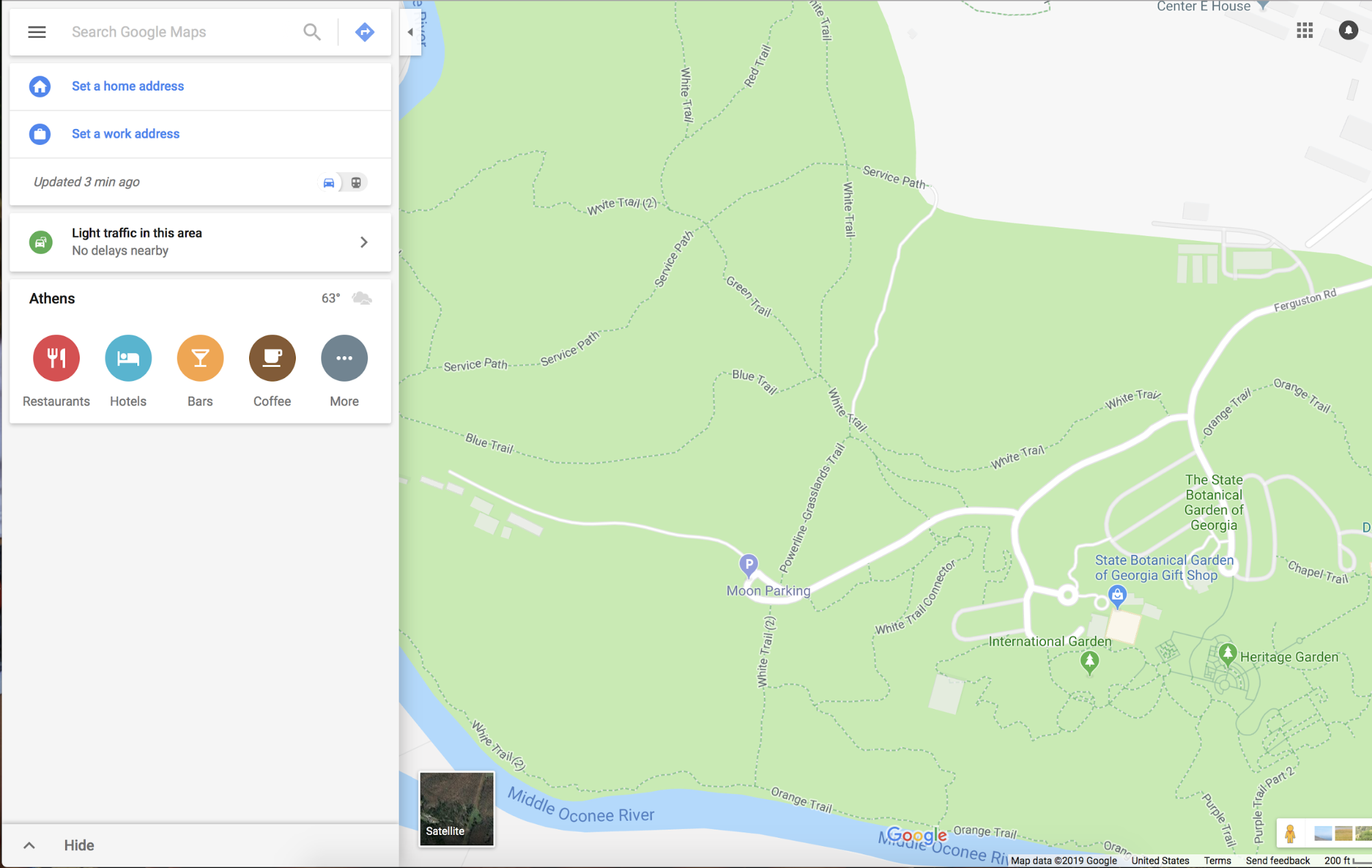
Some of the existing systems that provide solutions to the problem are Google Maps, Waze, Avenza, and Gaia GPS. Each of these covers a portion of the issue but there isn’t one that provides all of the functionality our users are looking for. For example, Waze finds the best route for users to take and allows them to report incidents, but only for driving on roads. Our website will provide similar functionality for walking on trails. While Google Maps does provide walking directions, users cannot report issues or share information relevant to others users walking the same paths. Also, Google Maps displays known walking trails, but does not allows users to search for trails nearby. Avenza offers many different USGS maps, but most of them do not line up with similar design/layout since they were designed at different times. Avenza also does not offer hiking trails, but has a variety of roads for the occasional driver and only major parks and forests are available. Gaia GPS has recently offered hiking trails as an extra overlay, but they do not offer any kind of social sharing feature or live obstacle reporting. Cairn is a safety oriented application that has a variety of safety features we plan to incorporate such as mapping where other users have gotten cellular service. While Cairn offers excellent safety features, it is very limited in helping hikers find new routes and expand their experiences. Aside from existing mapping apps, users can search for trails in their area by using search engines and checking park websites for maps, or use physical maps provided by parks/recreation centers if they have them. Through our research, we discovered that most users are currently using Google Maps to find trails.
Source: User Survey
Waze provides driving directions. The primary contribution of Waze is live user-reported incidents and features, such as police speed traps, accidents, and construction.
Image source: abcnews.go.com
Img source: google.com
Google Maps is the most widely used commercial mapping application. From a map data perspective, its strong points are driving and public transportation directions, as well as business data, such as restaurants and opening times. Features for hiking are limited, such as the lack of offline support for terrain and satellite data, as well as limited trail information.
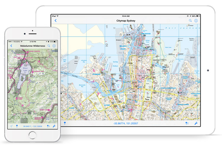
Image source: avenzamaps.com
Avenza Maps is a mapping application specifically design for hiking and offline use. It is designed around a grid of downloadable GeoPDFs. These PDFs can have a variety of types of information and can come from a variety of sources. Many states have their state park trail maps uploaded, giving location specific information not found elsewhere. These PDFs are static, however, so user-generated content cannot be added.
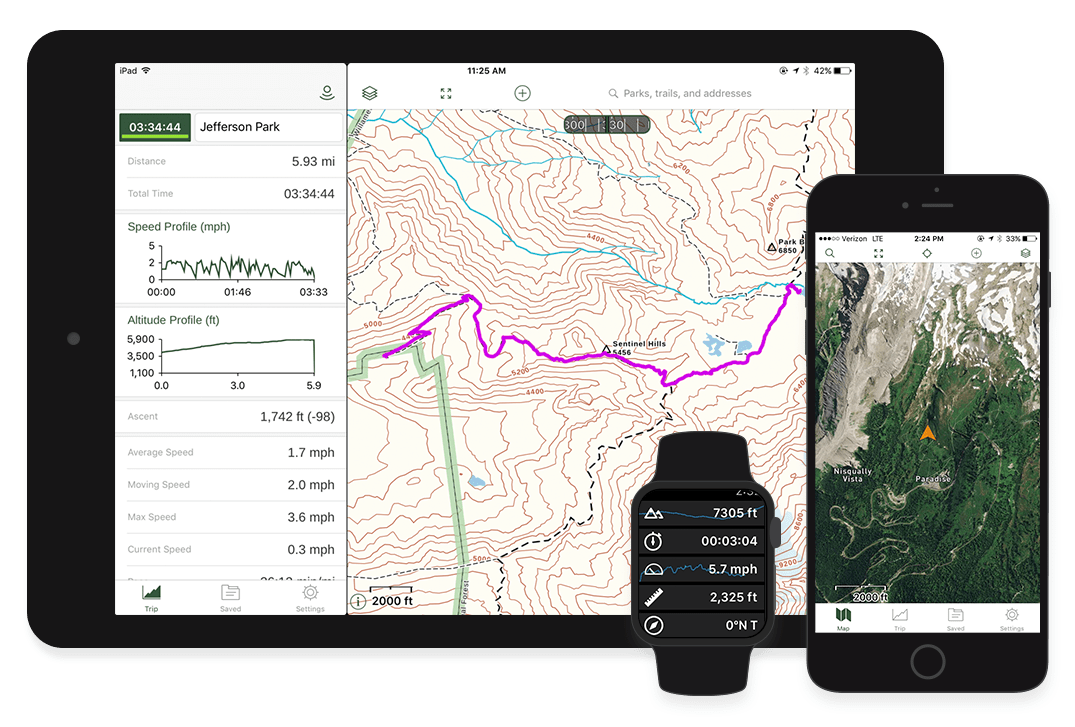
Image source: gaiagps.com
Gaia GPS is another outdoor-specific mapping application. It uses OpenStreetMap data, which allows it to have more detailed information about trails and foot-traffic related sites. It does not include any temporary user-reported events.
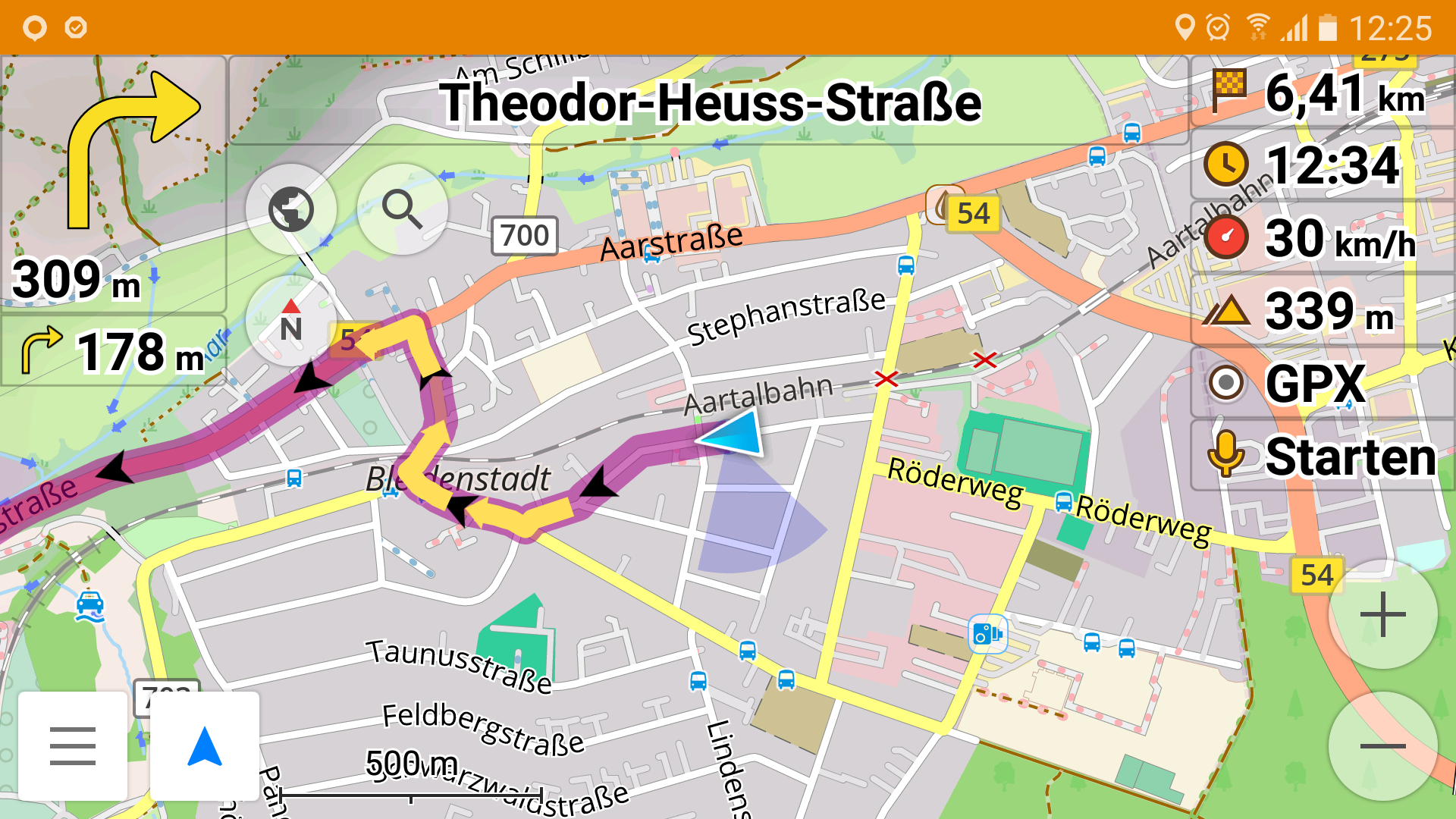
Image source: OsmAnd
OsmAnd is an open source OpenStreetMap based application. While it is more intended for driving directions, its use of OpenStreetMap data, robust offline support, and track recording make it useful for trail navigation. It also does not provide any mechanism for live event reporting other than editing of the base OpenStreetMap data.
Image source: cairnme.com
Cairn is a safety oriented hiking application. While you can download trail routes for offline use, the apps real utility comes with its safety features. This app allows: family members to constantly track the user, the user to set a time when they should finish the hike and alert someone if the user has not completed it, and crowdsources spots where others have found cell coverage on certain trails. This app checks all the boxes for safety, but has little else to offer the user for an improved hiking experience.
Our scenarios provided helpful information about the task environment. Since planning for hikes is mostly done in advance, the search and mapping mechanisms will mostly be used on desktops. However, the mapping function may be used if the user gets lost while on the trail, so it is important that this application is optimized for both desktop and mobile use. The reporting mechanism, used for providing information about hazards, good resting places, etc., is primarily going to be used on mobile devices, because these are things that users would report as they are hiking the trail. In one of our scenarios, a user posts a review of a trail on her desktop when she gets home, but we see this as something that may be done just as often on mobile devices. For example, if a user went hiking with a friend and the friend is driving home, the user may post a review from his/her mobile device on the way back. Since some of these tasks will be completed on mobile devices outdoors, it is important to design our system in such a way that users can clearly see elements of the interface even if it is very bright out.
The users would like an app that fits all of their hiking and safety needs, while expanding their hiking experiences through a network that gives them new routes, experiences, and methods of sharing those experiences. We learned that some existing systems help users find and use routes well or have excellent safety features, but few offer all this effectively in one app. Further, a social community where hikers can share routes, updated route information, or anything else about a hike is something many experienced hikers felt was lacking among existing applications. What sets Active apart is the ability of users to report content that is social in nature while offering top notch safety features.